

Reposted from the Cliff Mass Weather Blog
June 24, 2021
Incredible Temperatures Are Being Predicted and Confidence Is Now High That It Will Occur
There are two possibilities:
- The Northwest will soon experience one of the most incredible weather situations in many decades
- There is a major flaw in virtually all of our weather prediction system
Quite frankly, I am somewhat in shock looking at the raw forecast model predictions or the statistically calibrated versions of their output. The event being predicted is so extreme and so beyond expectation that my natural inclination is to dismiss it.
But I can’t. Multiple modeling systems are essentially doing the same thing. Large ensembles of many forecasts are showing similar solutions from most of the runs.
Let me show you the latest.
An important issue will be proximity to water and to get that right, high-resolution forecasts are important, so let me start by presenting the latest UW high-resolution simulations. The situation is so extreme that I had the colors altered to better define high temperatures.
Saturday will be the transition day. The temperatures at 5 PM, near the time of the maxima, will exceed 100 F in much of the Columbia Basin and in the northern Willamette Valley (e.g. Portland). 90s will invade the interior of southwest Washington and southern Puget Sound. Warm, but typical of the hottest days of a typical year.


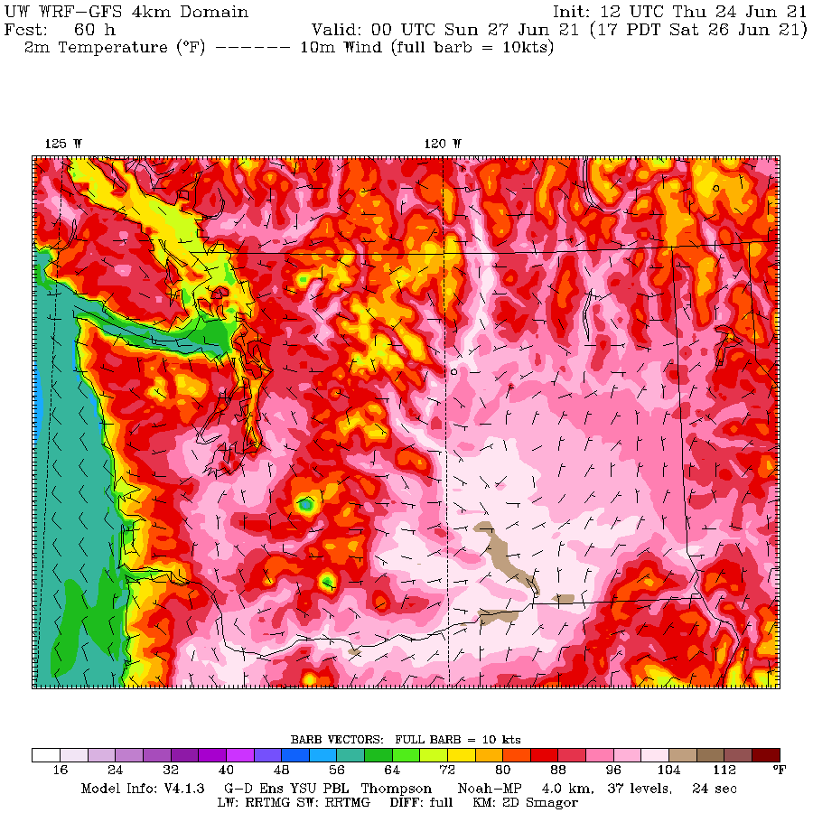
Sunday is something else. Temperatures in the Willamette Valley surge ABOVE 108F, as do the lower elevations of the Columbia Valley. Incredibly, some areas south of the Olympic Mountains get above 104. Can you imagine the temperature gradients near the coast… from the 60s to over 100F in a matter of a few miles? In central Puget Sound, temperatures will rise the 80s near the water to the upper 90s a few miles inland.

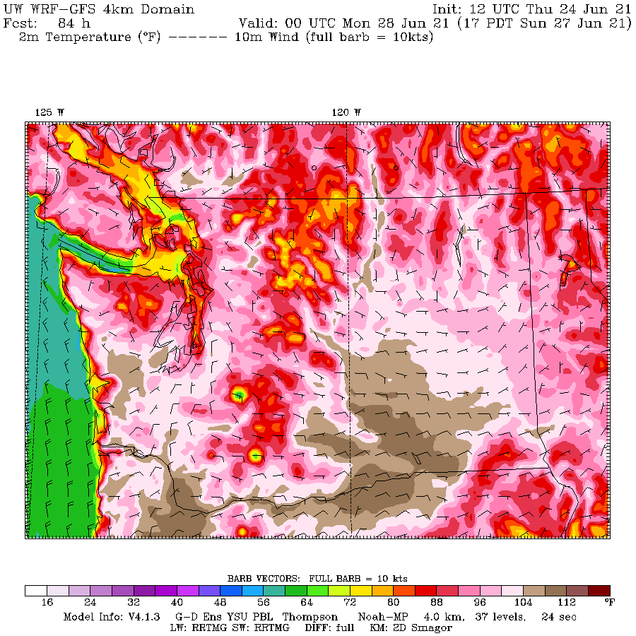
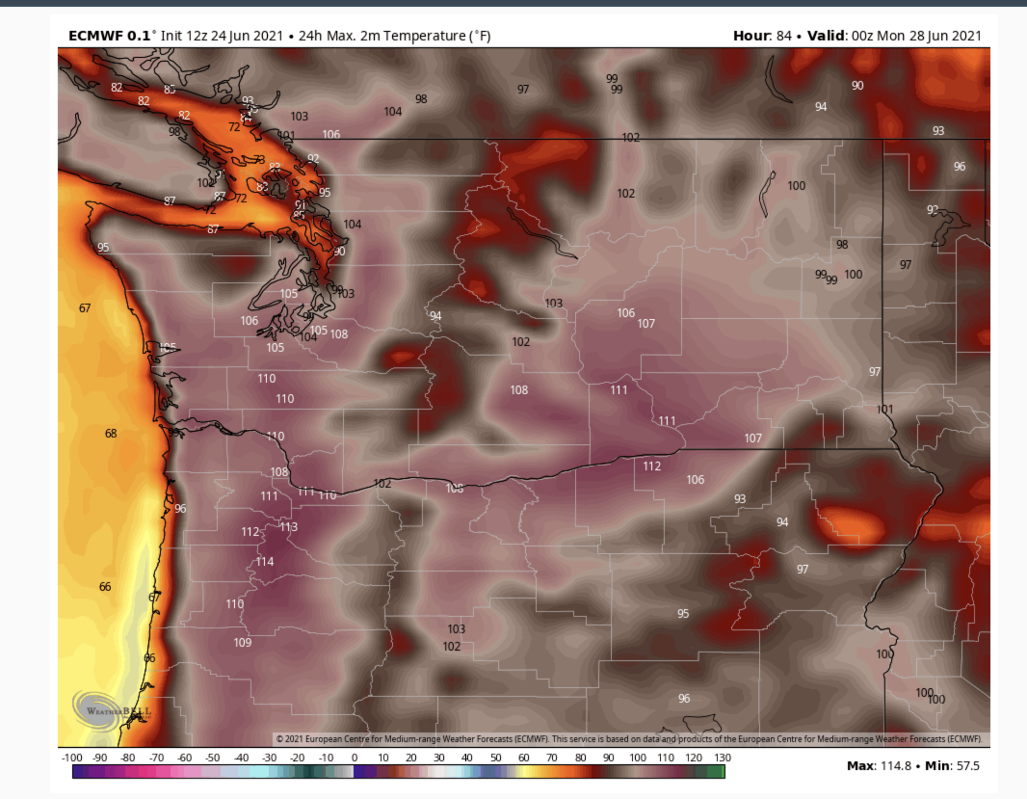
And now Monday at 2 PM. The model resolution is a bit less but the solution is absolutely amazing. Temperatures exceeding 108F will be found in and near the western Cascade foothills, thanks to the warming easterly flow descending the barrier. 104F and higher away from the water around Puget Sound. The Fraser River Valley will also be crazy warm.

If this forecast verifies virtually every major observing location in the western WA and Oregon interior will achieve their all-time temperature record. And several of these locations have observations that go back 70-120 years.
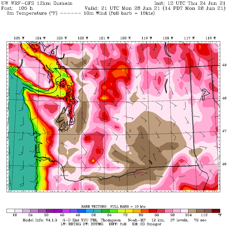
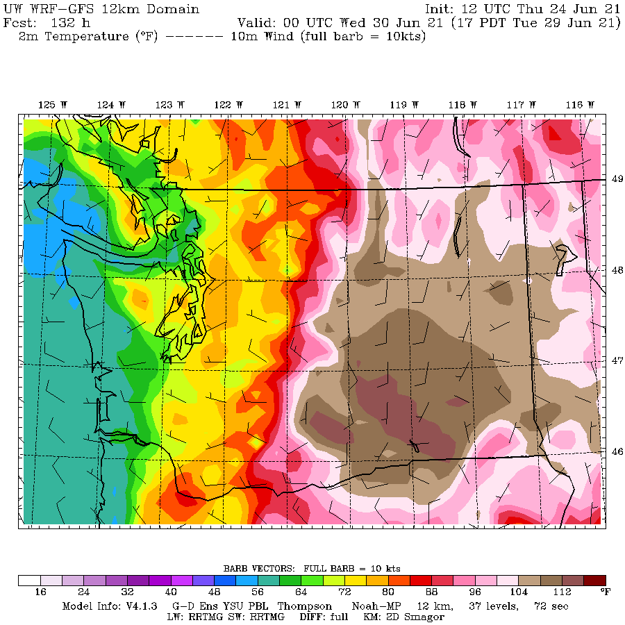
Later Monday, marine air will start to move in along the coast, resulting in Tuesday being a bit cooler west of the Cascade crest (see temperatures at 5 PM Tuesday below). But it will be showtime for the Columbia Basin where the model is going for temperatures OVER 112 F. It is not inconceivable that some locations in eastern Washington will tie or exceed the all-time temperatures record for the state (118F).

The highly skillful European Center model—absolutely different in every way (different data assimilation, different model, different developers)– is going for the same story.
For Sunday, 111F in Portland and 103 in Seattle.

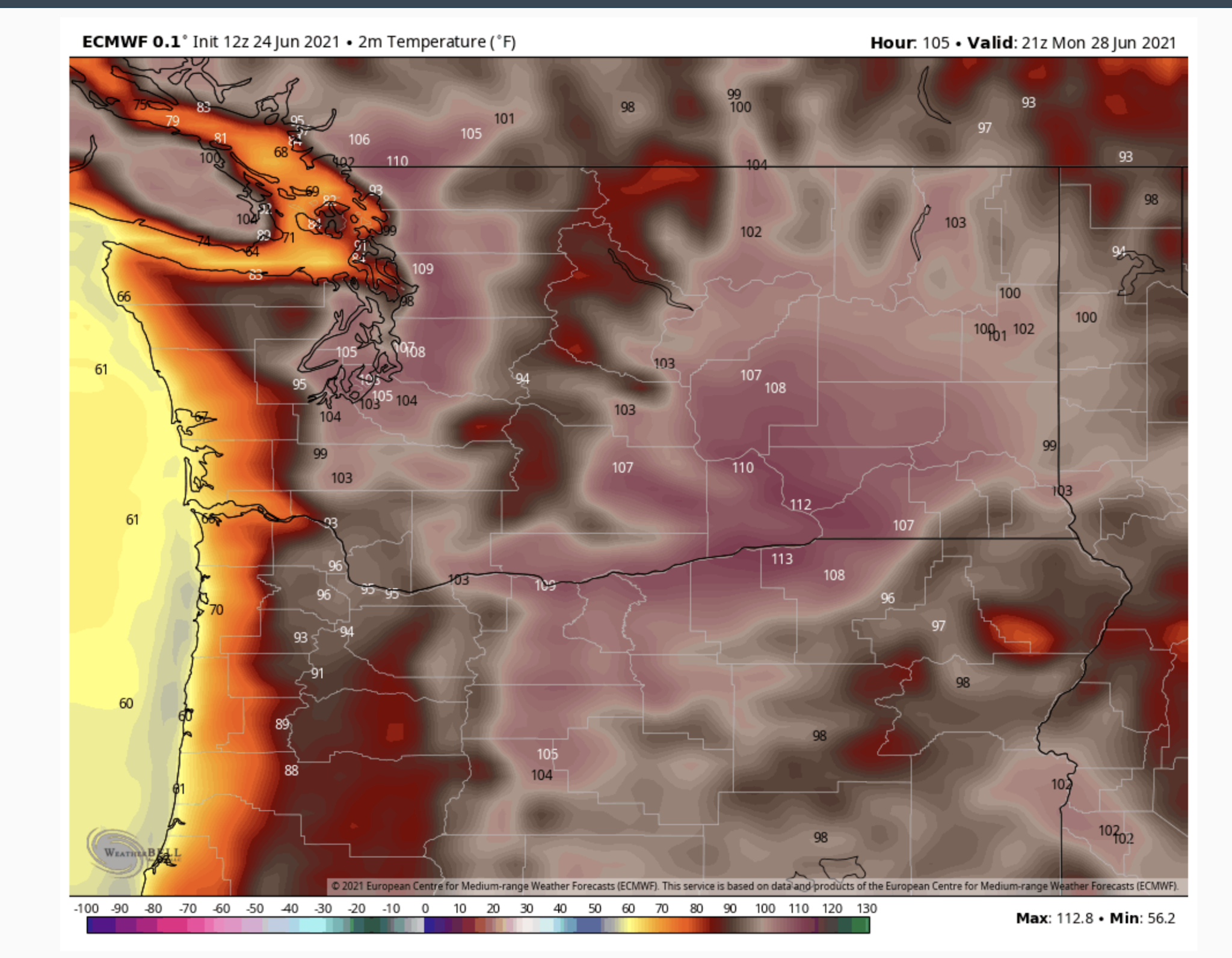
And for Monday at 2 PM an earth-shaking 108F in Seattle. You can see the cooling (orange colors) moving in on Monday afternoon.

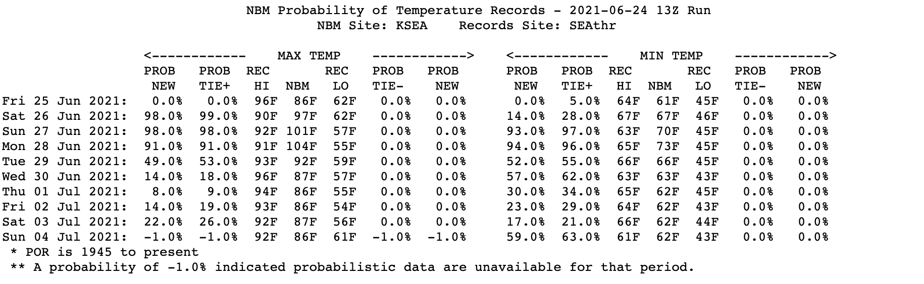
Let me say again: the ensembles of many forecasts show that this solution is the preferred one, with a high probability of verifying. The National Weather Service’s most advanced statistical postprocessing system (the National Blend of Models) that combines many forecasts in an optimal way is now going for 101F on Sunday and 104F on Monday at SeaTac Airport:


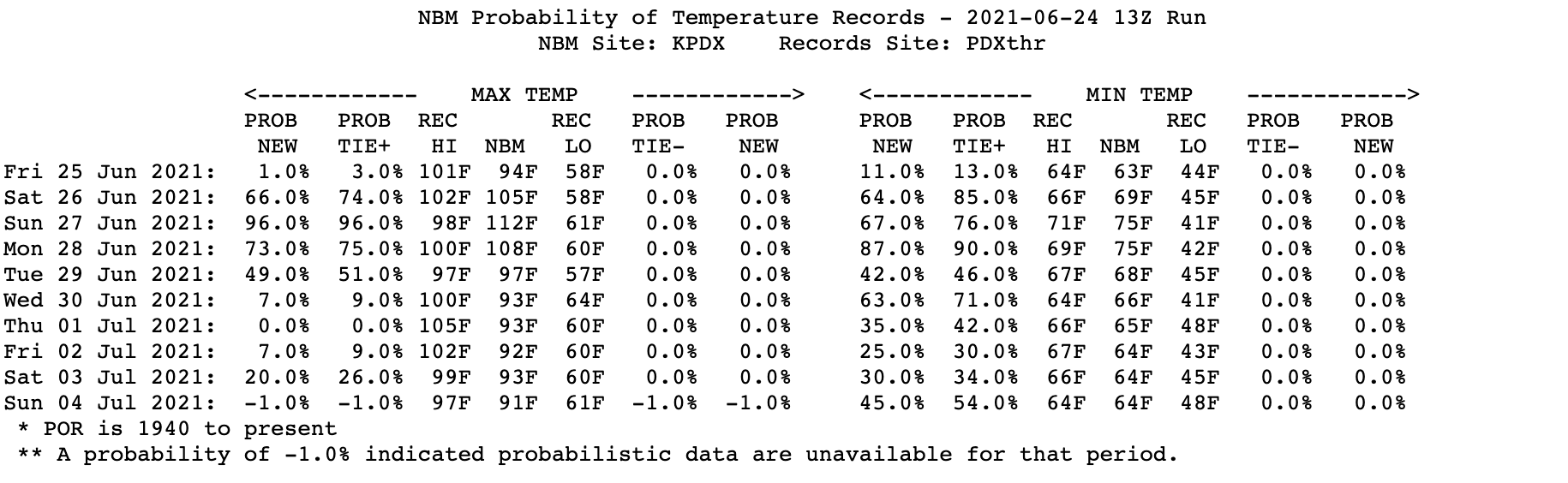
And at Portland: 101F on Friday, 105F on Saturday, 112 on Sunday, and 108F on Monday.

Finally, a number of people have asked about the role of global warming on this event. Is global warming contributing to this heatwave? The answer is certainly yes. Would we have had a record heatwave without global warming. The answer is yes as well.
Our region has warmed by up to 1-2F during the past fifty years and that will enhance the heatwave. Increasing CO2 is probably the biggest contributor to the warming
But consider that the temperature anomalies (differences from normal) during this event will reach 30-35F. The proximate cause of this event is a huge/persistent ridge of high pressure, part of a highly anomalous amplification of the upper-level wave pattern.
There is no evidence that such a wave pattern is anything other than natural variability (I have done research on this issue and published in the peer-reviewed literature on this exact topic).
So without global warming, a location that was 104F would have been 102F. Still a severe heat wave, just slightly less intense.


Let me end with the golden rule of temperature extremes: the bigger the temperature extreme the SMALLER the contribution of global warming. Think about that.
Now PLEASE do not send me emails or leave comments accusing me of helping “deniers” or calling me all kinds of names. I had enough of this from 350Seattle activists and Charles Mudede of the SeattleStranger. I have spent my life working on weather prediction and studying Northwest weather and am trying to communicate the best science, whether or not it fits some folks’ political agendas.
_________________________________________________
The New Edition of My Book: The Weather of the Pacific Northwest Will be Available in August
The book includes new chapters on the meteorology of Northwest wildfires and the weather of British Columbia, and the rest of the book is greatly enhanced. It is available for pre-order on Amazon.


via Watts Up With That?
June 24, 2021