

From CANADA to HAWAII, and from SWEDEN to SPAIN, the month of March is exiting like a “snowy lion” as rare accumulations continue to build — and things are forecast to turn even snowier as April rolls in.
The spring snowstorm that recently left a trail of wreckage in Saskatchewan and Alberta before cutting through central Manitoba has mostly moved into NW Ontario, according to Environment Canada; but it is not exiting quietly, reports cbc.ca: “howling winds are rattling, clanging and banging street lights, flag poles and anything else trying to resist the strong gusts.”
The highest amounts of snow fell around Flin Flon, which will likely top 30 cm (a foot) once the final count is in.
#mboutage We’re working on several outages across the province right now due to weather conditions. There are no estimated times for restoration yet, but we’re working as quickly and safely as we can. We’ll update Twitter when we have more info.— Manitoba Hydro (@manitobahydro) March 30, 2021

Winter is also taking its time departing the island of Hawaii.
With accumulating snow and ice, the National Weather Service (NWS) in Honolulu is extending a Winter Weather Advisory for the Big Island summits of Mauna Kea and Mauna Loa, reports weatherboy.com.
“Snow showers and fog will significantly reduce visibility at times, with periods of zero visibility,” the NWS warns.

Heavy April Snow to Pummel Multiple Continents Simultaneously
“Potent cold front crashes east across U.S., with plunging temperatures, wind and snow for some,” reads the headline of king of the warm-mongers the washingtonpost.com, who go on to alert their readers that the “strong cold front” is “packing a punch in the form of strong winds and fire weather concerns.”
The WP article largely sidesteps the intensifying cold and snow, and instead –and utterly predictably– lends its paragraphs to hyping the small wildfire threat.
Conversely, the headline syracuse.com opted for is much more on point: “Significant snow headed for Upstate NY,” opens the article, with a recent update reading: “A winter storm watch has been issued for parts of Upstate New York for up to 10 inches of snow on Thursday” — the watch will be in effect from late Wed through Thur.
“Greater than 4 inches of snow is looking more likely for much of the Finger Lakes region into the New York Thruway corridor, with isolated amounts of 6+ inches where the heaviest snow band sets up,” said the weather service office in Binghamton, which forecasts for the Finger Lakes and Central New York.
The heavy, wet snow will likely make driving treacherous, and weigh down trees and power lines enough to cause power outages. The initial ratio of snow-to-water will be about 4 to 1, meaning that 4 inches of snow contain the equivalent of an inch of rain. That’s extremely wet snow; but as temperatures plunge that ratio will drop to a something like 12 or 14 to 1, the weather service said, more typical of a winter snow.
“February-like blast to send temps crashing in Northeast,” reads a recent aol.com headline.
“A blast of cold air is projected to slash temperatures by 30-50 degrees Fahrenheit in much of the Northeast by April 1,” says senior Accuweather meteorologist Alex Sosnowski (that name is too perfect), who goes on to warn that the conditions will be “no joke,” with snow forecast to fall and accumulate as cold winds add to the winterlike feel later this week.
“It’s a roller coaster ride here in the Northeast,” said AccuWeather On-Air Meteorologist Brittany Boyer.
“You could actually call it weather whiplash,” continues Boyer.
“It’s going to go from feeling like spring to feeling like winter.”
The majority of Canada will also cop a blast of out-of-season cold and snow:

And in Europe, much of the continent can expect a rare April burial as the month progresses:

Asia won’t be spared either.
The mammoth mass of Arctic cold that has lingered in northern parts since mid-December, 2020 looks set to power into its fifth month:

The Sun is once again Spotless
Solar and geomagnetic activity are very low — the Sun is once again spotless.
Yesterday, a solitary spot was spotted on the northwestern limb.
The prominence, though weak, was photographed raining plasma onto the surface of the Sun:

Prominences are clouds of plasma held above the surface of the sun by magnetic fields, explains Dr Tony Phillips at spaceweather.com — a closer look at Tosi’s photo reveals state-sized “raindrops” falling back to the surface.
Magnetic forces holding the prominence up are clearly leaky.

Today, March 31, the Sun is once again blank, the above prominence has faded, and the quiet conditions are further prolonging the already historically-weak ramp-up to Solar Cycle 25.
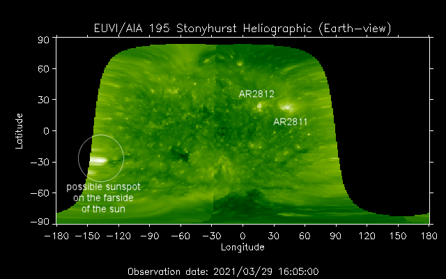
A spotless Sun is expected to continue for at least another 2 to 3 days, before a possible farside sunspot rotates Earthside, bringing with it a chance of renewed activity:

Today’s uneventful solar disc is a far cry from events on this day 20 years ago, continues Dr. Phillips.
The solar disk of March 31, 2001 (during the peak of SC23) was dominated a monstrous sunspot called AR9393 — the biggest sunspot of all of Solar Cycle 23:

AR9393 hurled a pair of CMEs toward Earth.
The first one struck on March 31, 2001, sparking a severe (G5-class) geomagnetic storm: sky watchers as far south as Texas and Mexico saw bright Northern Lights after the impact, while in Bishop, CA, home of spaceweather.com, Dr. Phillips observed “red and green auroras dancing for hours” over the Sierra Nevada mountains at latitude +37 degrees.
What a difference 20 years makes:

The COLD TIMES are returning, the mid-latitudes are REFREEZING in line with the great conjunction, historically low solar activity, cloud-nucleating Cosmic Rays, and a meridional jet stream flow (among other forcings).
Both NOAA and NASA appear to agree, if you read between the lines, with NOAA saying we’re entering a ‘full-blown’ Grand Solar Minimum in the late-2020s, and NASA seeing this upcoming solar cycle (25) as “the weakest of the past 200 years”, with the agency correlating previous solar shutdowns to prolonged periods of global cooling here.
Furthermore, we can’t ignore the slew of new scientific papers stating the immense impact The Beaufort Gyre could have on the Gulf Stream, and therefore the climate overall.


Prepare accordingly— learn the facts, relocate if need be, and grow your own.
Social Media channels are restricting Electroverse’s reach: Twitter are purging followers while Facebook are labeling posts as “false” and have slapped-on crippling page restrictions. EV has also been blacklisted by ad networks, meaning the site is no longer allowed to run advertising.
So, be sure to subscribe to receive new post notifications by email (the box is located in the sidebar >>> or scroll down if on mobile).
And/or become a Patron, by clicking here: patreon.com/join/electroverse.
The site receives ZERO funding, and never has. So any way you can, help us spread the message so others can survive and thrive in the coming times.
Grand Solar Minimum + Pole Shift
The post Heavy April Snow to Pummel Multiple Continents Simultaneously, as the Sun [once again] Fades to Blank appeared first on Electroverse.
via Electroverse

You must be logged in to post a comment.