
An Arctic chill descended as far south as Nevada over the weekend, delivering a record breaking snowstorm Saturday night into Sunday.
The valley saw up to 6 inches (15.2 cm). Carson City got around 3.5 inches (8.9 cm). While Mt. Rose Ski received 8 inches (20. 3 cm). Places near Echo Pass and South Tahoe even reported lake effect snow Sunday afternoon.
Conditions conspired to break a couple of records.
A total of 4.5 inches (11.4 cm) of snow fell at the Reno Airport this weekend, with 3.8 inches (9.7 cm) of that accumulating on Sunday alone — this comfortably eclipsed the old record for Sunday set exactly 100 years ago, in 1920, by 1.3 inches.

In addition, Reno smashed a daily low-max temperature record.
The city’s Airport struggled to a high of just 34F (1.1C) on Sunday — the coldest Reno has ever been on this date, busting the old record of 38F (3.3C) also set exactly 100 years ago, in 1920.
As reported by ktvn.com, it will now be easier for storms to roll through; “the ridge has been broken down”. In fact, another system is expected to move into Northern Nevada and California Friday, forecast to deliver heavy snow to the mountains.

Also, note the snowfall totals forecast for the surrounding states.
Feet upon feet of record breaking November snow are predicted to bury large parts of California, Utah, Colorado, Oregon, Idaho, Wyoming, Montana, and Washington this weekend. Stay tuned for updates — this looks BIG.
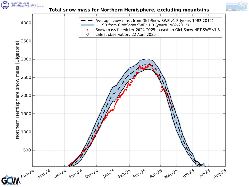
Such insane early-season totals will only increase the Northern Hemisphere’s already well-above average Snow Mass (shown below), to levels 400 gigatons above the seasonal norm, perhaps more.
This simply should not be happening in a warming world.
The powers that be are spinning a yarn.
The COLD TIMES are returning, the mid-latitudes are REFREEZING in line with historically low solar activity, cloud-nucleating Cosmic Rays, and a meridional jet stream flow.
Both NOAA and NASA appear to agree, if you read between the lines, with NOAA saying we’re entering a ‘full-blown’ Grand Solar Minimum in the late-2020s, and NASA seeing this upcoming solar cycle (25) as “the weakest of the past 200 years”, with the agency correlating previous solar shutdowns to prolonged periods of global cooling here.
Furthermore, we can’t ignore the slew of new scientific papers stating the immense impact The Beaufort Gyre could have on the Gulf Stream, and therefore the climate overall.


Prepare accordingly— learn the facts, relocate if need be, and grow your own.
Social Media channels are restricting Electroverse’s reach: Twitter are purging followers while Facebook are labeling posts as “false” and have slapped-on crippling page restrictions.
Be sure to subscribe to receive new post notifications by email (the box is located in the sidebar >>> or scroll down if on mobile).
And/or become a Patron, by clicking here: patreon.com/join/electroverse, and/or consider “allowing ads” for http://www.electroverse.net if you use a blocker.
The site receives ZERO funding, and never has. So any way you can, help us spread the message so others can survive and thrive in the coming times.
Grand Solar Minimum + Pole Shift
North America’s October Snow Cover is now the Highest in Recorded History: the new “Hockey Stick”
The post 100-year-old Temperature and Snowfall Records smashed in Reno, Nevada appeared first on Electroverse.
via Electroverse

You must be logged in to post a comment.