

Reposted from the Cliff Mass Weather Blog
The Reason for the Extreme Warmth on Monday–And My Podcast on the Heat Wave is Out
I think I understand why the temperatures in western Oregon and Washington will be so stunningly extreme on Sunday and Monday.
A unique combination of factors will come together to make the unthinkable possible. Forget the “heat dome” explanations found in the Seattle Times and some media outlets, or those saying that the extreme heat can only be explained by global warming.
I will call the phenomenon a downslope heat surge on the western slopes of the Cascades.
A relative of the extreme heat associated with Santa Ana winds in southern California, but with a twist.
An Unusual Collection of Ingredients
To get this amazing event, a series of ingredients had to occur at the same time and same place. To put it another way, it is like throwing several dice and having all of them come up with sixes.

Ingredient One: An unusually strong area of high pressure aloft over our region (known as an upper-level ridge), associated with sinking air and unusually warm temperatures.
At the surface, this feature is associated with high pressure to the east of the Cascade crest, which tends to produce weak offshore (easterly) flow. Such easterly flow keeps the cooling influence of the Pacific Ocean away.
Why did we get this high amplitude ridge? It is associated with a highly amplified wave pattern in the eastern Pacific, which may have been caused by a tropical system interacting with the jet stream (see below). This is the result of natural variability ( I did a paper exploring this issue with climate models)

Upper level (500 hPa pressure, about 18,000 ft) for 5 AM this morning. Red indicates higher than normal pressures/heights, blue below normal. Note the highly amplified wave pattern
Ingredient Two: An Approaching Trough of Low Pressure That Creates Strong Easterly/Downslope Flow over the Western Slopes of the Cascades
The key to this situation is that there will be high pressure inland and an approaching area of low pressure (called a trough) that will approach our coast. Between these two features, a zone of very large pressure difference will be created, which will be associated with strong southeasterly flow.
To illustrate, there is the weather chart for around 5000 ft (850 hPa pressure) that shows the key features. A narrow zone of strong southeasterly flow will be created that will descend the western slopes of the Cascades.

The air will start off warm, with origins from the desert southwest, but will warm further as it descends the Cascades into western Washington. Why warm more? Because the air will be compressed as it descends into western Washington.
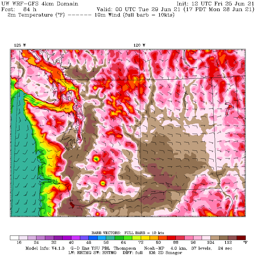
The absolutely unbelievable temperatures at 5 PM Monday illustrate what will happen.
Surface temperatures will get above 112F over and near the western slopes of the Cascades. Large portions of western Oregon and Washington away from the water will be above 104F.

All this is happening during a favorable time of the year (the sun is powerful and days are long).
Check out my podcast for more of the story:
You can also use your favorite streaming service (see below)
Listen on Apple Podcasts
Listen on Spotify Podcasts
Listen on Google Podcasts

My Views on Global Warming and Climate Change – Weather with Cliff Mass
- My Views on Global Warming and Climate Change
- A Wet Weekend Ahead and Why the New York Smoke Had Little to Do With Climate Change
- Where do you get the best weather forecasts? And a cool weak ahead.
- Why is freezing at 32°F? And a snowy mountain forecast for this weekend.
- The end of La Nina and an El Nino Winter Ahead
via Watts Up With That?
June 26, 2021

You must be logged in to post a comment.