

NWS Kansas meteorologists warn of a “widespread killing freeze” after unprecedented October cold and snow laid waste to the record books.
As reported by kansas.com, the National Weather Service (NWS) in Wichita issued a winter weather advisory on Sunday running through 1 a.m. Tuesday for central, south-central and southeast Kansas. The forecast called for snow, sleet and freezing rain: “Plan on slippery road conditions,” reads the advisory. “The hazardous conditions will impact the morning and evening commutes.”
The city wasn’t able pre-treat its roads with salt on Sunday due to wet conditions, but efforts belatedly began in the early hours of Monday: “We did activate our full response as of midnight,” Ben Nelson, a city public works administrator, said Monday morning. “Once our crews got on scene, we deployed all 60 of our trucks and began to apply the salt and the sand mix across all 1,500 lane miles of arterial (roads) and the 300 lane miles of our secondary and school routes,” Nelson said.
The flakes started falling early Monday morning, as forecast — however, that original NWS advisory vastly underestimated the volume. The snow continued throughout the morning, to levels far greater than city crews had expected.
So much snow fell that city workers needed to use the plows on the front of the dump trucks to clear the roads, something crews try to avoid because 1) it significantly slows down the trucks, and 2) it runs the risk of scraping the already applied salt off the road.
https://platform.twitter.com/embed/index.html?dnt=true&embedId=twitter-widget-0&frame=false&hideCard=false&hideThread=false&id=1320796161851203587&lang=de&origin=https%3A%2F%2Fwordpress.com%2Fread%2Ffeeds%2F85002459%2Fposts%2F2988462098&theme=light&widgetsVersion=ed20a2b%3A1601588405575&width=550px
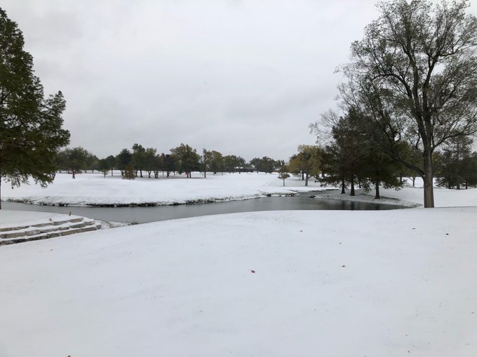
After initially forecasting just a trace, NWS “officially” measured 1.3 inches of snow as of 10:50 a.m. Monday–although the scene on the ground looked far worse in places. Still, that official reading of 1.3 inches almost tripled the previous Oct 26 record of 0.5 inches set way back in 1913 (solar minimum of cycle 14).
Monday’s snow also set another, even more impressive record. According an NWS tweet, Monday witnessed “the most snow Wichita has ever received this early in the season.”
https://platform.twitter.com/embed/index.html?dnt=true&embedId=twitter-widget-1&frame=false&hideCard=false&hideThread=false&id=1320754636656181249&lang=de&origin=https%3A%2F%2Fwordpress.com%2Fread%2Ffeeds%2F85002459%2Fposts%2F2988462098&theme=light&widgetsVersion=ed20a2b%3A1601588405575&width=550px
This beat-out the previous earliest 1+inch of snow, set on Oct 28, 1905:

Record cold accompanied the record snow, further hampering city clearing efforts. Monday morning’s low of 24F broke the Wichita record for coldest ever low for the date — the old mark being the 25F set in 1957.
https://platform.twitter.com/embed/index.html?dnt=true&embedId=twitter-widget-2&frame=false&hideCard=false&hideThread=false&id=1320781892908511232&lang=de&origin=https%3A%2F%2Fwordpress.com%2Fread%2Ffeeds%2F85002459%2Fposts%2F2988462098&theme=light&widgetsVersion=ed20a2b%3A1601588405575&width=550px
The city also broke its lowest-max for Oct 26, busting the 32F, also set in 1957 — though this record has yet to be officially logged.
Looking forward, the NWS Wichita hazardous weather outlook predicts “a widespread killing freeze” Monday night, to be followed by a wintry mix of precipitation across much of the area on Tuesday, continuing into early Wednesday morning.
Additional snow and ice accumulations are possible through Wednesday afternoon, and as kansas.com points out: “Any measurable snowfall on Tuesday in Wichita would set a record, as the weather service has never recorded snow accumulations on Oct 27. The record low temperature of 23 degrees, set in 1957, and the coolest high of 37 degrees, set in 1911, are both in jeopardy.”
The COLD TIMES are returning, the mid-latitudes are REFREEZING in line with historically low solar activity, cloud-nucleating Cosmic Rays, and a meridional jet stream flow.
Both NOAA and NASA appear to agree, if you read between the lines, with NOAA saying we’re entering a ‘full-blown’ Grand Solar Minimum in the late-2020s, and NASA seeing this upcoming solar cycle (25) as “the weakest of the past 200 years”, with the agency correlating previous solar shutdowns to prolonged periods of global cooling here.
Furthermore, we can’t ignore the slew of new scientific papers stating the immense impact The Beaufort Gyre could have on the Gulf Stream, and therefore the climate overall.


Prepare accordingly— learn the facts, relocate if need be, and grow your own.
Social Media channels are restricting Electroverse’s reach: Twitter are purging followers while Facebook are labeling posts as “false” and have slapped-on crippling page restrictions.
Be sure to subscribe to receive new post notifications by email (the box is located in the sidebar >>> or scroll down if on mobile).
And/or become a Patron, by clicking here: patreon.com/join/electroverse, and/or consider “allowing ads” for http://www.electroverse.net if you use a blocker.
The site receives ZERO funding, and never has. So any way you can, help us spread the message so others can survive and thrive in the coming times.
Grand Solar Minimum + Pole Shift
The post “Killing Freeze” hits Wichita, Kansas as all-time Cold and Snow Records Fall appeared first on Electroverse.
via Electroverse
“Killing Freeze” hits Wichita, Kansas as all-time Cold and Snow Records Fall

You must be logged in to post a comment.