


THIS POST IS A CRITICAL REVIEW OF A REPORT BY THE WASHINGTON POST THAT „Two major Antarctic glaciers are tearing loose from their restraints, scientists say“: https://www.washingtonpost.com/climate-environment/2020/09/14/glaciers-breaking-antarctica-pine-island-thwaites/
PART-1: WHAT THE WASHINGTON POST REPORT SAYS
By Chris Mooney: September 15, 2020 at 2:03 a.m. GMT+7
Two Antarctic glaciers that have long kept scientists awake at night are breaking free from the restraints that have hemmed them in, increasing the threat of large-scale sea-level rise. Located along the coast of the Amundsen Sea in West Antarctica, the enormous Pine Island and Thwaites glaciers already contribute around 5 percent of global sea-level rise. The survival of Thwaites has been deemed so critical that the United States and Britain have launched a targeted multimillion-dollar research mission to the glacier. The loss of the glacier could trigger the broader collapse of the West Antarctic ice sheet, which contains enough ice to eventually raise seas by about 10 feet. The new findings, published Monday in the Proceedings of the National Academy of Sciences, come from analysis of satellite images. They show that a naturally occurring buffer system that prevents the glaciers from flowing outward rapidly is breaking down, potentially unleashing far more ice into the sea in coming years. The glaciers’ “shear margins,” where their floating ice shelves encounter high levels of friction that constrain the natural flow of ice, are progressively weakening and in some cases breaking into pieces. The stresses that slow down the glacier, they are no longer in place, so the glacier is speeding up. While many of the images have been seen before, the new analysis suggests that they are a sign of further disintegration to come. It’s just the latest in a flurry of bad news about the planet’s ice. Arctic sea ice is very close to — but likely to not quite reach — a record low for this time of year. Last month, Canada lost a large portion of its last major Arctic ice shelf. And in Greenland, the largest still-intact ice shelf in the Northern Hemisphere, just lost a large chunk of ice, equivalent in size to roughly two Manhattan islands, according to the Geological Survey of Denmark and Greenland. Experts there blamed the fracture on a strong general warming trend and temperatures that have been “incredibly” high in the northeast of Greenland in recent years. Ice shelves are vast floating platforms that extend across the surface of the ocean at the outer edge of marine-based glaciers. As they flow over the water, these shelves freeze onto mountainsides and islands and anchor themselves to bumps in the seafloor. In this way, the shelves provide a braking mechanism on the natural outward flow of ice. The buttressing effect occurs in the shear margins, where faster-flowing ice meets ice that is more static and stable, often because it is moored to some part of the landscape. In these places, the ice frequently crumples and contorts, a visible indication of the powerful stresses that it is under. But when those stresses become too much, ice breaks. That’s what’s now happening in West Antarctica, the new research argues, suggesting that warm ocean water has thinned the ice shelves out enough from below that they became brittle. At the same time, and for the same reason, the glaciers themselves began to flow outward faster. The resulting forces led the shear-margin ice to break into pieces which means that the glacier, less constrained, will now be able to add ice to the ocean even faster. For the Pine Island Glacier, the new study finds that while the cracking and fraying at the shear margin dates to 1999, it accelerated in 2016. Even more concerning is the Thwaites Glacier. Here, again, the breakdown of the shear margin has increased in recent years. This is important work. The processes playing out in Antarctica appear to have already reached their completion in parts of Greenland, where one of the largest glaciers, Jakobshavn, no longer has any significant ice shelf at all. When it lost that shelf around the year 2000, Jakobshavn’s rate of ice loss steeply increased. The 79 North glacier still has a major ice shelf, as do some of Greenland’s other northernmost glaciers, but many of these have lost considerable size in recent decades. The new paper shows that the Amundsen Sea Embayment ice shelves have gone through most, but not all, of the Jakobshavn. Warming ocean thinned the ice shelves, this reduced buttressing, this let the non-floating ice move faster, contributing some to sea-level rise and also starting to break the sides of the ice shelves, but additional acceleration could occur if further fracture and ice-shelf loss should occur. Multiple ice-shelf collapses have already been seen in Canada, Greenland and the warmer Antarctic Peninsula, where the onetime Larsen A and Larsen B ice shelves fractured and, today, no longer exist. When the ice shelves are damaged by climate change, as we saw in the Antarctic Peninsula in the last several decades, their buttressing effect is reduced and the ice streams speed up and raise sea levels. The speed-up increases damage, a positive feedback which is not good news. If a similar process plays out in the Amundsen Sea of West Antarctica, where Pine Island and Thwaites are, the sea-level consequences could be enormous. Over the past six years, the western and central parts of the Pine Island ice shelf have shrunk by about 30 percent, from about 1,500 square miles down to closer to 1,000 square miles. In other words, an area about the size of Los Angeles has been lost. This shear margin is so damaged we think it preconditions this ice shelf for destabilization on the longer term. These are the first signs we see that Pine Island ice shelf is disappearing. This damage is difficult to heal.
PART-2: WHAT THE REFERENCED RESEARCH PAPER SAYS
Damage accelerates ice shelf instability and mass loss in Amundsen Sea Embayment. Christopher Shuman, Bert Wouters, Frank Pattyn, Jan Wuite, Etienne Berthier, and Thomas Nagler. PNAS September 14, 2020 https://doi.org/10.1073/pnas.1912890117. Edited by Chad Greene, NASA Jet Propulsion Laboratory, Pasadena, CA, and accepted by Editorial Board Member Jean Jouzel July 29, 2020 (received for review July 29, 2019) ABSTRACT: Pine Island Glacier and Thwaites Glacier in the Amundsen Sea Embayment are among the fastest changing outlet glaciers in West Antarctica with large consequences for global sea level. Yet, assessing how much and how fast both glaciers will weaken if these changes continue remains a major uncertainty as many of the processes that control their ice shelf weakening and grounding line retreat are not well understood. Here, we combine multisource satellite imagery with modeling to uncover the rapid development of damage areas in the shear zones of Pine Island and Thwaites ice shelves. These damage areas consist of highly crevassed areas and open fractures and are first signs that the shear zones of both ice shelves have structurally weakened over the past decade. Idealized model results reveal moreover that the damage initiates a feedback process where initial ice shelf weakening triggers the development of damage in their shear zones, which results in further speedup, shearing, and weakening, hence promoting additional damage development. This damage feedback potentially preconditions these ice shelves for disintegration and enhances grounding line retreat. The results of this study suggest that damage feedback processes are key to future ice shelf stability, grounding line retreat, and sea level contributions from Antarctica. Moreover, they underline the need for incorporating these feedback processes, which are currently not accounted for in most ice sheet models, to improve sea level rise projections. Pine Island Glacier (PIG) and Thwaites Glacier (TG) in the Amundsen Sea Embayment are responsible for the largest contribution of Antarctica to global sea level rise (i.e., ∼5% of global sea level rise). Both glaciers show distinct changes in recent decades driven by changing atmospheric and oceanic conditions that cause enhanced ocean-induced melting of their floating ice shelves. Due to this enhanced melting, PIG and TG calving fronts retreated and their ice shelves thinned, decreasing the buttressing effect they exert on the upstream glaciers. As a result, both glaciers have accelerated and thinned and their grounding lines have retreated. Under these conditions and in combination with a retrograde bed, PIG and TG are considered prone to marine ice sheet instability with the potential loss of their ice shelves and with large consequences for sea level rise. Yet, quantifying the future timing and magnitude of these instabilities remains difficult as many of the key processes and their boundary conditions are poorly known or not accounted for in ice sheet models. SIGNIFICANCE OF THESE FINDINGS: The Pine Island Glacier and Thwaites Glacier in the Amundsen Sea Embayment are among the fastest changing outlet glaciers in Antarctica. Yet, projecting the future of these glaciers remains a major uncertainty for sea level rise. Here we use satellite imagery to show the development of damage areas with crevasses and open fractures on Pine Island and Thwaites ice shelves. These damage areas are first signs of their structural weakening as they precondition these ice shelves for disintegration. Model results that include the damage mechanism highlight the importance of damage for ice shelf stability, grounding line retreat, and future sea level contributions from Antarctica. Moreover, they underline the need for incorporating damage processes in models to improve sea level rise projections.
PART-3: CRITICAL COMMENTARY
This research and the interpretation of its findings by the press follow a well established pattern in climate change research of polar ice dynamics. This pattern driven by a well-entrenched confirmation bias in climate research that all polar ice melt events are caused by AGW climate change such that it is necessary only to determine the possible catastrophic consequences of the observed ice melt in terms of such things as polar bear ecology or sea level rise without the requirement to provide evidence of the assumed causation. This bias is particularly egregious in the identification of ice melt that are geographically isolated and in terms of time scale can only be interpreted as isolated events rather than long term trends. The attribution to anthropogenic global warming and thereby to fossil fuel emissions is simply assumed. It remains only to provide creative impacts of the observed ice melt in terms of sea level rise or ecological impacts under various various assumed conditions that „could“ occur and that can be presented as events much too hazardous to risk. All of these assessments lead to the implied and assumed conclusion that such ice melt events can and must be attested or attenuated by taking climate action in the form of reducing or eliminating the use of fossil fuels. This kind of research is neither science nor credible but is driven to acceptance by the fear of the ice melt events in terms of such things as sea level rise. The credibility of such ice melt research findings is further degraded when the ice melt events in question are very location specific in areas known to be geologically active where isolated location specific ice melt events are best understood in terms of geological activity underneath the ice and not the atmosphere above the ice. Both Antarctica and the Arctic are geologically very active. Specifically, the West Antarctic Ice Sheet and the Antarctic Peninsula region where the Pine Island glacier and the Thwaites glaciers are located is geologically very active with active volcanism underneath these glaciers.
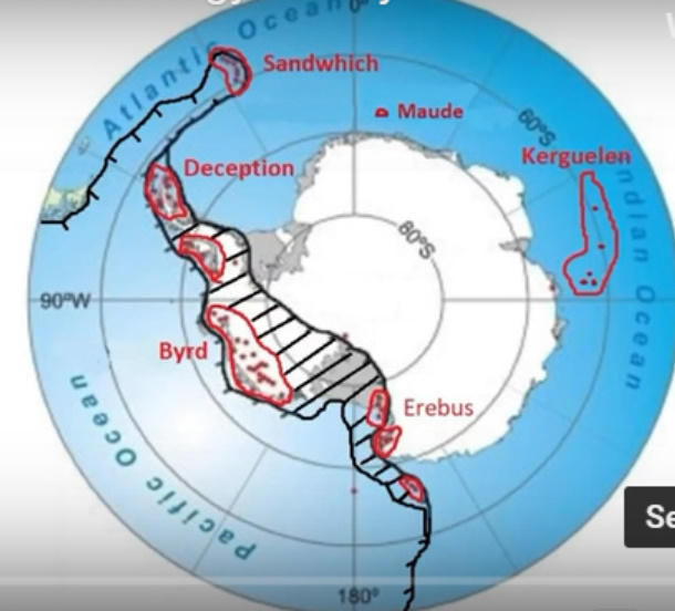
The principal geological feature of West Antarctica is the West Antarctic Rift (WAR) and its major fault lines shown in the graphic below. The rift is 700 miles wide and 4,000 miles long with 149 known active volcanoes. A rift is an area where the lithosphere is being pulled apart by plate tectonics. In the diagram below, the black cross hatched area shows the location of the West Antarctic Rift. Red outlines identify regions of volcanic activity with red dots within them showing locations of the volcanoes. Two such red circles that are particularly significant in terms of geological activity and geothermal heat are Deception Island and the Marie Byrd Mantle Plume area. As the lithosphere is pulled apart, its middle thins and brings hot mantle rocks closer to the ocean waters and aids in heat transfer from the mantle to the ocean. See graphic below provided by the University of Sydney [LINK]. Here, the color red indicates intensity of geothermal heat. The WAR contains 149 active volcanoes.
Within this giant rift structure are specific regions of intense geological activity and geothermal heat. The Northwest extension of the WAR, with a string of active volcanoes, goes into the Antarctic Peninsula and out into the ocean. The West Antarctic Rift (WAR) consists of a number of rift valleys between East and West Antarctica. A rift valley is a lowland region that forms in the middle where a rift occurs. They tend to be long, narrow, and deep. The WAR includes the Byrd area of West Antarctica. The Byrd area is the main portion of the WAR.
The Marie Byrd Mantle Plume Hotspot is shown below. It includes the Thwaites Glacier and the Pine Island Glacier. A mantle plume hotspot is a large area where magma comes up from the mantle of the inner earth, goes up through layers of rock until obstructed when it spreads out into a mushroom shape over a widespread area. If it is under a sufficient pressure, the magma can break through to the atmosphere as a volcanic eruption. Red shaded areas identify locations of melting and the darker the red color, the more intense the melting. These red areas are found close to the edge of the Marie Byrd Mantle Plume. These data suggest that the role of the mantle plume in the observed ice melt events cannot be overlooked.
IN BRIEF, NO EVIDENCE IS PROVIDED FOR THE CAUSATION OF THE OBSERVED ICE MELT EVENTS BY AGW. THE ASSUMED CAUSATION BY FOSSIL FUEL EMISSIONS IS REJECTED ON THAT BASIS. ALSO, IN LIGHT OF THE GEOLOGICAL FEATURES OF THE REGION WHERE THESE ICE MELT EVENTS WERE OBSERVED, IT CANNOT BE ASSUMED THAT THE ICE MELT EVENTS PRESENTED MUST HAVE BEEN CAUSED BY ANTHROPOGENIC GLOBAL WARMING OR THAT THEY CAN BE ARRESTED OR MODERATED BY TAKING CLIMATE ACTION IN THE FORM OF REDUCING OR ELIMINATING THE USE OF FOSSIL FUELS.

RELATED POST ON CONFIRMATION BIAS IN CLIMATE SCIENCE: https://tambonthongchai.com/2018/08/03/confirmationbias/
RELATED POSTS ON THE GEOLOGICAL FEATURES OF THE POLAR REGIONS
LINK#1: https://tambonthongchai.com/2019/06/27/antarctica/
LINK#2: https://tambonthongchai.com/2019/07/01/arctic/


Posted by: chaamjamal on: September 17, 2020
